
Step-by-Step Guide for Applications to the Capital Stream of the Rural Transit Solutions Fund
Step-by-Step Guide for Applications to the Capital Stream of the Rural Transit Solutions Fund

Table of Contents
- How to Submit an Application to the Rural Transit Solutions Fund
- Step One: Register for an INFC Applicant Account
- Step Two: Managing your INFC Applicant Account
- Step Three: Apply for Funding
- Step-by-Step Instructions for Capital Project Applications
- Section 1 – Applicant Identification
- Section 2 – Project Details
- Section 3 - Environmental Assessment
- Section 4 - Project Finances and Supplementary Information
- Estimated Project Schedule
- Section 5: Required Documents
- Section 6: Attestation
- Annex A: Duty to Consult with Indigenous Peoples and Impact Assessment Act Requirements
- Annex B: How to Create a KML File
How to Submit an Application to the Rural Transit Solutions Fund
Introduction
- Before you begin your application, please ensure that your organization is eligible for funding under the Rural Transit Solutions Fund in accordance with the eligible recipients as outlined in the "Who Can Apply" section of the Application Guide for the Capital Projects Stream of the Rural Transit Solutions Fund (available on the website and via the applicant portal). Infrastructure Canada (INFC) will also validate your organization's eligibility when your application has been submitted. You should also review the requirements for supporting documentation that will need to be attached in the applicant portal as outlined in the "Supporting Documents" section of the Application Guide.
- Applicants must register for an INFC Applicant Portal Account to access the Rural Transit Solutions Fund application form. By accessing your Applicant Portal Account through the INFC Applicant Portal, you will be able to create, save, edit, and submit applications to the Rural Transit Solutions Fund, as well as view your organization's list of submissions through "My Dashboard".
- Applicants who are unable to apply through the INFC Applicant Portal are asked to reach out to the Rural Transit Solutions Fund Team at rtsf-fstcr@infc.gc.ca.
- Applicants who have an existing INFC Applicant Account can skip to Step Two.
Step One: Register for an INFC Applicant Account
- Enter the INFC Applicant Portal. Please use the most recent version of the following supported web browsers:
- Microsoft Edge
- Apple Safari
- Google Chrome
- Mozilla Firefox
- Internet Explorer (not recommended)
- Click New User
- Confirm you have read the Privacy Notice Statement
- Register your account by:
- Providing a valid e-mail address
- Creating a username and password
- Activate your account by logging out after saving and returning to the sign in page. (Please note that you may get an error message if you do not complete this step).
Passwords must contain characters from at least three of the following four classes: uppercase, lowercase, digit, and non-alphanumeric.
Create your organization's profile
Have you previously applied to an INFC program?
Applicants who have previously applied to an Infrastructure Canada (INFC) program should have an existing profile created using information provided in previous applications. You can find your profile by searching the Existing Organization Name list. Once you find your organization's profile, review the information provided and ensure that it is up to date. Please edit your organization's profile if necessary. If your organization is not found, you can proceed to create a New Organization profile.
How do I edit my organization's profile?
You can edit your organization's profile once you have made an INFC Applicant Portal Account by clicking on Profile.
- Once you enter your Profile page, click on Manage Organizations. Here, you will be able to locate your organization.
- Edit as needed and click Save.
Are you a New Applicant to an Infrastructure Canada program?
- If you are a new applicant, create your organization's profile by clicking New Organization.
- Fill in the required fields including:
- The organization's full legal name
- Contact information
- Organization address
- Organization type
- Click Submit.
- Once you have created your organization's profile, find your organization from the Existing Organization Name list.
- Enter the name and contact information for your organization.
- Click Save.
- Sign out by clicking on your name in the top right corner, selecting Sign out and sign back into your INFC Applicant Account. (Please note that you may get an error message if you do not complete this step).
Step Two: Managing your INFC Applicant Account
With your INFC Applicant Account, you can apply to the Rural Transit Solutions Fund. The INFC Applicant Portal is the place to access your organization's dashboard, application forms and online resources.
Managing Permissions – Account Administrator/Owner
If you are the first person in your organization to register for an INFC Applicant Portal account, you will automatically be the primary contact for your organization's account and be assigned the role of Account Administrator/Owner.
As Account Administrator/Owner, you will be responsible for:
- Reviewing and approving (or declining) requests from other members of your organization to access the INFC Applicant Portal and the Rural Transit Solutions Fund application form.
- Determining whether an approved team member(s) has "read only" capabilities or "update" (populating an application) capabilities.
- Determining whether an approved team member(s) can Attest to and/or Submit project applications.
- Determining whether an approved team member(s) can be your "delegate", which permits them to have the same account privileges as you and undertake the above-noted actions on your behalf (as the team Account Administrator/Owner).
How to grant access to the Rural Transit Solutions Fund application to members of your organization
For other members of your organization to access the INFC Applicant Portal and work on the Rural Transit Solutions Fund Application Form, you must grant them permission through your Profile page. It is only after you have made your INFC Applicant Portal Account that other members of your team can proceed to make their own INFC Applicant Portal accounts and start an application.
First, have your team members create their own INFC Applicant Portal Accounts. When asked to identify the Lead Applicant Organization, ensure that they "link" themselves to your organization by selecting it from the Existing Organization List. It is only through this process that they will be linked to your organization and be able to access your organization's Rural Transit Solutions Fund Application. Once your team members have created their accounts, you will receive an e-mail notification titled: "Your action required".
Next, go to your Profile page. Click on Manage Permissions. Here, you will see a list of individuals who are requesting access to the INFC Applicant Portal.
- Click the drop-down menu located next to their name and account information.
- Click Edit.
- Answer the questions as prompted:
- Enable Portal Access
- Portal contact role
- Update
- Enable updating of application contents
- No ability to modify the organization's contact and account information
- No ability to attest and/or submit the Application Form
- Read
- Read-only mode
- Update
- Status
- Can Attest
- Can Submit
- Is Delegate
Once you have assigned roles to your team members and saved this information, they will be able to see your Rural Transit Solutions Fund application form in their own accounts under My Dashboard. Any changes that are made and saved to your application form by your team will be visible to all accounts linked to the application form.
My Dashboard
Your dashboard will list your ongoing and completed application forms at INFC. Use the dashboard to navigate to your application form(s) and keep track of the progress and status of your application(s). You do not need to complete your online application in one attempt. The application can be saved and edited as many times as necessary.
Apply for Funding
To apply, you will find a link to the application form on the Applicant Portal. There is no limit on the number of applications that can be submitted by an eligible applicant. Each project can be submitted as its own application. Alternatively, projects can be bundled into a single application.
An application, regardless of bundling, must describe how the project(s) will support the objectives of the Rural Transit Solutions Fund and satisfy the merit criteria of the program.
Release Notes
The Release Notes tab in the Applicant Portal is where INFC will make general announcements pertaining to the application process. Check back in this tab from time to time to see if there is any news and/or updates.
Help
While using the Applicant Portal, applicants will have access to support services at any stage of the application process. To contact support services, click on "INFC support" in the bottom left corner of any page within the Applicant Portal. If, at any time, your account is inaccessible, please email the support team at crmsupport-soutiengrc@infc.gc.ca.
Applicant Guides
You will find links to the Application Guide for the Capital Projects Stream of Rural Transit Solutions Fund and other applicant resources in this section.
Step Three: Apply for Funding
After creating and confirming your organization account, to access the Rural Transit Solutions Fund Application Form:
- Click Apply for Funding
- Click Apply for the Public Transit Funds (PTF)
- Click Apply for the Rural Transit Solutions Fund
- Confirm the "Privacy and Eligibility" Statements
- Read the Privacy and Third-Party Notice Statement and confirm that you have read the statement by selecting "Yes".
- Read the Organization Eligibility Self-Assessment and confirm that your organization meets all the eligibility requirements for funding under the Rural Transit Solutions Fund and that you are duly authorized to submit this application on behalf of the Organization by selecting "Yes". Refer to the Rural Transit Solutions Fund Applicant Guide for details on organization eligibility.
Step-by-Step Instructions for Capital Project Applications
Important tips when preparing your application
- All applicants are encouraged to prepare their application in an external document and then copy and paste their answers into the fields within the application.
- To edit or delete information that is displayed in table format, click on the icon to either edit or delete.
- Unless otherwise noted, the maximum character count for questions requiring a narrative answer (text box) is 2,000 characters.
- Frequently, click "Save" to save your answers. This allows you to pause and resume work on your application without losing any information.
- Questions marked with a red asterisk (*) are required and will need to be completed to validate and submit your application.
- Once you have completed all questions in a section, click Validate. In addition to saving your work, this will verify that you have submitted all the required information, and the tab at the top of the page will turn green.
- All sections must be validated in order to submit your application to INFC.
Create a New Project Submission
What is the total federal contribution you are requesting? In the drop-down menu you will be able to select either Conventional Transit Solution (Up to $3 million) or zero-emission transit solutions (up to $5 million). This does not represent the total funding request but rather the funding ceiling.
Lead Applicant
The name of your organization which was created as part of your applicant profile should be prefilled here.
What is the total federal contribution you are requesting?
In the drop-down menu you will be able to select either Conventional Transit Solution (Up to $3 million) or zero-emission transit solutions (up to $5 million). This does not represent the total funding request but rather the funding ceiling.
Eligible Organization Type
The dropdown menu will give you the following options, and you will be able to select only one:
- Province
- Territory
- Municipality
- Local or Regional Government
- Public Sector body
- Indigenous governing body
- Indigenous Development Corporation
- Not for profit mandated to improve Indigenous outcomes/serve Indigenous communities; or
- Registered not-for-profit organization
Indigenous Group
If you selected either Indigenous governing body, Indigenous development corporation or not-for-profit mandated to improve Indigenous outcomes/serve Indigenous communities as your Eligible Organization Type, you will need to identify the Indigenous Group. Using the dropdown menu please select from:
- First Nations
- Inuit
- Métis
- Multiple Indigenous/Other
If "Multiple Indigenous/Other" is selected, using the textbox provided, please specify.
Project Title
In this section you will be asked to provide, in 300 characters or less, a concise but meaningful project title and the location of the project (e.g., Purchase of a zero-emission vehicle to provide on-demand transportation service in [community name, province, territory]).
Section 1 – Applicant Identification
To prevent losing your work, please click "Save and Continue" in each section or click on "Save All". Use "Validate" when you have completed all questions in this section to check that all mandatory sections are complete.
Lead Applicant
The Lead Applicant* will be prefilled from your Account Profile. When you have selected your organization, press "Save and Continue".
Lead Applicant Contacts
The system will ask for a Primary Contact* and a Secondary Contact. The contact names of individuals that you entered in your profile will appear in the drop-down menu. Once you have made your selections, press "Save and Continue".
Project Details
Project Title*
You should see the project name you previously entered prefilled.
Does the project involve a zero-emission solution?*
Please choose your project type. Choose either:
- Yes (project can receive up to $5 million)
- No (project can receive up to $3 million)
Are you partnering with other organization(s) to deliver the project?*
Please select "Yes" or "No"
If you selected "Yes", there will be an option to add partner organization details.
Partner Organizations; Organization Type; Address Line 1; Role of the Partner. (If Yes is selected above).
The name of the organization should be the legal name. In terms of describing the role of partners, please provide a brief description of the mandate of the partner organization(s) along with their roles and responsibilities in relation to the delivery of the proposed project. Note: Paid contractors and professional service providers should not be identified in this section.
Press "+ Add Partner Organizations", and you may add other partner organizations. Remember to click on Disk to save each partner and press "Save and Continue" when you are finished.
Project Location
Please specify where the community transit solution will operate (within which municipality(ies)/ region(s)/town(s)).
Select from the list (or choose other if it does not exist). Indicate where the project is located.
Click"+ Add Project Location" and select the "Province or Territory" where the project is located. Also, select "City/Municipality" where the project is located. A minimum of one must be selected to submit.
You may add multiple project locations. Click "+ Add Project Location" to add additional locations and click on disk to save the entry.
Remember to press "Save and Continue" when you are finished.
Additional information
You may specify the name of the location in this text box if it is not listed among the options in the drop-down menu. This section can also include more on routings for your project (e.g., Community A to Community B, and so on) and articulate the location of the transit hub.
Name, Name of the Document +Add KML Asset Map.
- A KML Asset map is required to submit an application. For more information on how to create a KML Asset map, please see Annex B of this document.
- Select "Add" and name and attach at least one KML file that identifies the project's asset(s) location(s). The file should show the project location and footprint of project assets. If you upload more than one KML file, please ensure the name of each file includes the project name and specific details about the file you are attaching (e.g., "KML-charging station-Province of XX").
- The KML file will be used for the Duty to Consult with Indigenous peoples and Impact Assessment Act (IAA) requirements.
- If your project only involves the acquisition of rolling stock, your KML could represent the area that will be covered by the transit solution.
Is the project within the boundaries of a Modern Treaty or self-government agreement?*
Please select "Yes" or "No." Additional information on Indigenous rights is available on the Crown-Indigenous Relations and Northern Affairs Canada website.
If yes, please indicate which Modern Treaty or self-government agreement?
Please fill in the text box, as applicable.
Please indicate if there are specific obligations that relate to the project in the treaty or agreement.
Please fill in the text box, as applicable.
When you are done completing this section, please select "Save and Continue".
To prevent losing your work, please click "Save and Continue" in each section or click on "Save All". Use "Validate" when you have completed all questions in this section to check that all mandatory sections are complete.
Section 2 – Project Details
Project Rationale
Please choose your project type (select all that apply).*
Please note definitions related to the type of service can be found in the Application Guide under "Definitions". The options in the menu are:
- Fixed route service
- Ride sharing or ride hailing
- On-demand service (demand-response)
- Mobility as a Service (MAAS)
- Intermodal Hubs
- Installation of charging stations
- Purchase of software (e.g., trip planning or booking platform)
- Other (please specify)
If other is selected – You may specify the type of project in the following section when you describe the project.
Please describe the project that you are undertaking. (For example, what capital assets do you propose to purchase, and how will they be used to advance the community transit solutions?)*
Provide a meaningful description of the work to be completed, including the nature of the project and a description of all major quantifiable components. Describe key output(s) the project will generate. What are you looking to achieve with the project? Describe the main benefit(s) including information on the communities and any vulnerable populations that will benefit. Please note that this information may be used by Infrastructure Canada for public reporting.
Does your proposed project plan address specific challenges outlined in your Municipal Plan or alternate local community planning documentation?*
Please select "Yes", "No" or "N/A."
If Yes, please explain.*
If "Yes" is selected, please explain any linkages the proposed project has to a transit plan (e.g., municipal/regional/feasibility studies or local municipal, and regional strategies, plans, Band Council Resolutions).
Does the project intend to link more than one Census Metropolitan Area (CMA) or Census Agglomeration (CA) with a population of 50,000?*
Please select "Yes" or "No"
Does the project intend to cross Province/Territory boundaries?*
Please select "Yes" or "No". (Note: interregional travel is permitted if the distances meet the day-to-day travel requirement of the fund).
Does the project intend to cross international boundaries?*
Please select "Yes" or "No". Note: international routes (e.g., to the United States) would not be eligible under the Fund.
Is your project intended for daily use?* (i.e., The proposed transit solutions intends to offer a same-day return service).
Please select "Yes", "No", or "N/A".
Please describe the current level of access to public transportation options in the community.*
Please include information on any existing transit services in the community or communities where the project will operate, including those run by your organization or your delivery partners. Describe the degree to which any existing services are inclusive and broadly available to the community and/or how the existing service may not meet the needs of some community members. (Note: a taxi service is not considered a public transit service).
Will your project serve Indigenous populations?*
Please select "Yes" or "No".
If yes, select all that apply*
- First Nations
- Inuit
- Métis
- Multiple Indigenous/Other
If Multiple Indigenous/Other is selected, then specify.*
How will this project be developed with Indigenous peoples? Please explain.*
If your proposed project will serve Indigenous peoples, please describe how (process and timelines) Indigenous peoples have been/will be involved in its development.
Describe the direct and ongoing benefits that this project will bring to Indigenous people.*
Please describe the direct and ongoing results/outcomes that are expected to benefit Indigenous people in the project's development and implementation.
Please describe the community population, including any vulnerable populations, that is expected to use the proposed service.*
Please provide examples of the vulnerable populations that are expected to benefit from the project. Please identify how your project will serve vulnerable populations. If possible, you should list the sources of information (e.g., letters of support from community service organizations, studies, reports, and public consultations, etc.) that support your analysis.
Note: Vulnerable populations include but are not limited to Indigenous peoples, racialized peoples, youth, persons with disabilities, seniors, linguistic minorities, newcomers to Canada (e.g., immigrants, refugees), women, persons experiencing poverty, persons experiencing homelessness, and 2SLGBTQI+.Please explain any benefits that are expected for the local community from the rural transit solution. As applicable, include quality of life, safety and security, and/or access to employment opportunities.*
Describe the expected benefits to the targeted population(s) resulting from the implementation of the project. Include as many aspects of the benefits as possible in this description (e.g., access to health services, access to public goods/government services, aging-in-place, safety and security, access to education, living standards (poverty reduction), social connection, and access to culture/recreation activities). Please identify, if possible, how these benefits were identified (e.g., studies, reports, public consultations, etc.).
Please explain how the rural transit solution is expected to contribute to the economy of the community.*
Describe the potential economic benefits expected from the implementation of the proposed project. Examples may include: estimates of job creation, access to employment/training, and access to local business (local spending). Please note that descriptions and estimates provided should be specific to the project and community.
Please explain how the project will be managed.*
Please explain how the project will be managed, including 1. The overarching governance structure/management team; 2. Objectives/milestones for the implementation of the project; 3. Policies and procedures for the procurement of asset(s); 4. Where you intend to procure your assets; 5. How budget/cashflow will be monitored and reported on to ensure project remains on budget and in alignment with potential federal funding.
Please explain how success of the project will be measured.*
Please provide information on the evaluation framework, including project outcomes and performance measurement strategy that demonstrates how data collected will be used to improve the transit solution over time.
Please explain the strategies being considered that will ensure that the transit solution is sustained beyond the proposed capital purchases.*
Please explain any long-term financial sustainability plans, including how any ongoing operational costs (e.g., insurance, licensing and permit, fuel, training, and maintenance, etc.) will be covered through planned revenues (e.g., fares) or other sources of long-term financial support.
Please explain how the proposed system will include measures to encourage more people to use public transit.*
Please describe planned efforts or strategies to encourage/promote the adoption of the proposed transit solution by the community (e.g., increase ridership), including strategies targeting vulnerable populations. If possible, please describe how you decided on specific promotional activities (e.g., radio, print media, social media, transit apps, ,etc.) and any design characteristics aimed at user experience, such as ease, comfort, safety, time sensitivity, utility, enjoyment, and affordability.
Will there be any public consultations and/or participation?*
Please select "Yes" or "No".
If yes, please explain.*
Please provide information regarding planned public consultations and/or participation related to the project. This would include the type of activity (e.g., consultations, meetings, surveys) along with the date, location, audience). Explain how these activities contribute to the development of the proposed project.
Please provide details on community and stakeholder engagement activities that have been conducted in relation to the project, including those that have included Indigenous peoples, if applicable.*
Please provide information on community and stakeholder engagement activities. This would include the type of activity (e.g., consultations, meetings, surveys) along with the date, location, audience). Explain how these activities contribute to the development of the proposed project.
Asset Type
It is important to identify the asset type and activities that apply to the project using the asset lists below. This is information is essential for INFC to determine both Environmental Impact Assessment requirements and Indigenous consultation requirements that would apply to the project. All projects must comply with the Impact Assessment Act and the Canadian Environmental Assessment Act (2012), Indigenous consultation and accommodation obligations, and modern treaty obligations. It is therefore critical that the correct asset type and activities are identified. Depending on the asset type and level identified, you may be asked to supply additional information.
Please note that depending on where the project is located, an environmental impact assessment may be required prior to undertaking certain activities. Any Indigenous consultation requirements identified for the project would also need to be completed prior to undertaking certain activities.
Before selecting the asset type for your project, please review the entirety of Level 1, 2 and 3 assets lists and ensure you are familiar with all the activities required for your project, to allow you to select the most appropriate asset types from the list, and that these align with the description of the project.
Each asset of the project will need to be created individually. Using the "Add" buttons under the appropriate level(s), select the applicable "Asset Type"; and "Work Description" receiving investments for your project, and specify the "Length (km)" and asset "Count" (number of assets), as applicable. The drop-down menus will display the following items.
Level 1 – Asset Type and Work Descriptions
Physical works - Replacement of existing assets
- Replacement of sidewalks, cross-walks, pavement markings, street marking, signage, curb dividers, bike racks, washrooms, lockers, lights, benches, greenery, speed bumps, raised barriers
Physical works – Installation of new assets or enhancement of existing assets in developed areas
- Sidewalks
- Cross-walks
- Pavement markings
- Street Marking
- Signage
- Curb dividers
- Lights
- Speed bumps
- Raised barriers installed to existing transportation routes (installed for protection of active commuters)
- Ramps for accessibility, hand railings, wheelchair accessibility, installation to existing transit facilities
Transit
- Installation of charging stations (on developed land, minimal ground disturbance, no vegetation clearing required)
- Upgrading existing Transit Stations (installation of technology, station improvements/retrofits on developed land)
- Retrofits of conventional fuel buses to ZEB (zero-emissions buses)
- Upgrades to the interior of buses, installation of driver shields, installation of securing belts, driver barriers, ventilation, sanitation systems
- Upgrades to electronic systems, fare collection system, mobile communications systems, installation of electronic equipment tv's, monitors
- Upgrades to public sector commuter ferry infrastructure (e.g., installation of technology, ventilation, sanitation systems)
- Installation of bus stops, bus shelters and bike racks that are not on federal lands (are less than 100 m2 in area, and not within 15 m of waterbody)
Level 2 – Asset Type and Work Description
Public Spaces
- Curb Extensions – in a developed area
- Cross-walks (Pedestrians crossing – installation of fully activated signaled safety crossing in a developed area)
- Ramps for accessibility, hand railings, wheelchair accessibility – installation to active transportation multi-use pathways
- Upgrades, retrofits, modification of existing public spaces that are located on municipal or provincial lands that are developed or previously disturbed (includes existing pedestrian tunnel retrofit)
Transit
- Retrofits, rehabilitation, modification, upgrades of existing bus depot, transit facility, commuter hub on municipal lands or industrial park
- Installation of charging stations on undeveloped land (less than 100 m2) – Project on Federal Lands may have EA requirement, may have DTC requirements
- Expanding existing Transit Stations (1000 m2 or less on developed land)
- Developing new transit Facility (1000 m2 or less on developed land
Level 3 – Asset Type and Work Description
Transit
- Installation of charging stations (more than 100 m2 on undeveloped land) may require vegetation clearing (removal of trees, bush, including roots, works taking place within 15 m of a waterbody)
- Developing new transit facility on underdeveloped land (1,000 m2 or less)
Project is not described by any of the above
If the project is not described by any of the options, you may check the box.
Rolling Stock and Other Capital Assets
Does your project include the purchase or replacement of rolling stock?*
Please select "Yes" or "No".
If Yes, a series of drop down menus will appear according to the following fields:
Asset Type
- Truck (3-6 seats)
- Car (5-7 seats)
- Van (5-11 seats)
- Shuttle/Mini-Bus (12-15 seats)
- Bus (16-60 seats)
Description
- Electric
- Gas/Diesel
- Hybrid
- Propane
- Other
Other
If you identified "other' in the description list, you may provide details here.
Count
The number of assets as per the identified asset type.
Name of Document
In this section you can upload supporting documentation, e.g., vehicle quotes or descriptions.
Press the disk icon to save. You may add more rolling stock assets as applicable by pressing "+Add Rolling Stock".
Does your project include the acquisition of other Capital Assets?*
Please select "Yes" or "No"
If yes, two fields will appear where you can provide more information: "Type of assets: specify" and "Number of assets: specify"
If your project includes other assets than those identified in the form, you can add other assets in this section by clicking on "+Add Asset".
Accessibility Standard
As applicable, does the project meet or exceed the highest published accessibility standard (e.g., the Canadian Standards Association Technical Standard Accessible Design for the Built Environment (CAN/CSA B651-12, or newer), in addition to applicable provincial or territorial building codes, and relevant municipal by-laws?*
Please select "Yes", "Not Applicable", "Unsure or Unknown"
Climate Considerations
Describe the current and future climate risks facing the project over its entire lifespan. For a proposed process and methodology for assessing the climate hazard for your project you may wish to consult Infrastructure Canada's Climate Lens General Guidance Annex G.
For more information, please see the Climate Change Considerations section of the Application Guide for the Capital Stream of the Rural Transit Solutions Fund.
Are you considering assessing the option of using low carbon technologies (e.g., zero-emission vehicles) to deliver your public transit solution?*
Please select "Yes", "No" or "N/A"
If yes, please explain.*
Please provide further details in this text box.
Based on current and future-looking climate data, is the project in a location that is, or is expected to become, at risk or vulnerable to climate-influenced natural hazards such as flooding, wildfire risk, extreme heat, permafrost thaw or coastal erosion?*
Please select "Yes", "No" or "N/A."
If yes, provide a brief description of the current and future climate risks facing the project over its entire lifespan.*
Please provide further details in the text box.
Provide a brief list of all the climate change parameters (e.g., increasing precipitation, heatwaves, lightening events etc.) that were considered in your analysis of current and future climate risks.*
Please provide further details in the text box.
Are you employing measures that increase the resiliency of your project and your community to climate impacts?*
Please select "Yes" or "No."
If yes, describe or provide examples of project elements that been implemented to address the project's identified climate risks and increase resiliency of your community and/or your project.*
Please provide details in the text box.
If you identified climate risks but have not presented any planned resilience measures, please provide an explanation
Please provide further details in the text box, as applicable.
To prevent losing your work, please click "Save and Continue" in each section or click on "Save All". Use "Validate" when you have completed all questions in this section to check that all mandatory sections are complete.
Section 3 - Environmental Assessment
All projects under the Permanent Public Transit Program are required to comply with "horizontal federal requirements" namely the Impact Assessment Act and the Canadian Environmental Assessment Act (2012), Indigenous consultation and accommodation obligations, and modern treaty obligations, and must meet or exceed the highest published accessibility standard (e.g. the Canadian Standards Association for the Technical Standards Accessible Design for the Built Environment (CAN/CSA B651-12 or newer), in addition to applicable provincial or territorial building codes, and relevant municipal by-laws.
This section may be required depending on the type of Assets selected in Section 2. See Annex A of this document for additional aid with the Detailed EA Project Description, Environmental Assessment (EA) - Indigenous Consultation Checklist and Environmental Assessment (EA) Questionnaire.
Section 4 - Project Finances and Supplementary Information
Applicants must provide estimated costs; rounded up to the dollar.
Total Estimated Project Cost*:
This portion should outline the expected costs of the project based on researched and documented cost estimates. This should consider the total costs – not only the Federal Contribution requested through the Rural Transit Solutions Fund, but also the applicant's share of the costs, along with the total from other contributors. Please consult the Application Guide for a list of eligible and ineligible expenses under the "Budgeting" section.
Requested Federal Contribution from the Rural Transit Solutions Fund.*
Please state the total funding request under the Rural Transit Solutions Fund. This amount must be based on Eligible Costs, not total costs. Projects involving conventional transit solutions can receive up to $3 million in federal support while projects based on zero-emission vehicles can receive up to $5 million. A reminder that INFC will not provide additional payments for costs overruns.
A list of maximum funding limits based on organization type can be found below.
Eligible organization |
Maximum Rural Transit Solutions Fund contribution (% of eligible capital expenses) |
Maximum Federal Contribution from all sources (% of capital expenses) |
Total Canadian (federal provincial, territorial, and municipal) Government stacking (% of capital expenses) |
|---|---|---|---|
Applicant is located in a province or is a not-for-profit organization |
80% |
80% |
100% |
Applicant is located in a territory and/or an Indigenous recipient |
100% |
100% |
100% |
Applicant is a provincial government |
40% |
40% |
100% |
Applicant is a territorial government |
75% |
75% |
100% |
Applicant's Share of Total Cost.*
Please indicate your financial contribution as a share of the total estimated cost. This refers to the amount of total costs that your organization will contribute and that is not part of the federal funding being requested. You will then be asked to provide details regarding other contributors.
Other Contributors
Please fill out the fields as applicable.
Name of Contributor/Other Contributor.
Enter the legal name of the organization or entity.
Contribution Amount
Please round up the dollar value of the contribution amount to be provided by the organization/entity.
Funding Secured?
Please select "Yes" or "No".
Is there a letter of support?
Please select "Yes" or "No".
Upload document:
Please attach the letter of support here.
Once you have filled out the fields, press on the disk icon to save. Then you may add other contributors to the project by clicking "+Add another Contributors"
Total from Other Contributors:
This field will be populated based on the information provided under "Other Contributors".
Please make sure that the summation of the Request Federal Contribution from the Rural Transit Solutions Fund, Applicant's Share of Total Cost and Total from Other Contributors equals the Total Estimated Project Cost. To be considered, an applicant must demonstrate that funding has been secured.
Project Cash Flow Table
In this section you can add multiple project components (e.g., fixed assets, rolling stock) in the fields, and their estimated cost by Pressing "+Add a Project Component". The field will appear as per the below.
Please note that project components should be consistent with your asset request. You will also be asked to provide a breakdown of the estimated eligible expenditure per fiscal year. If the Project Component is not eligible (e.g. drivers salary, please leave the Estimated Eligible Expenditure at zero. Consequently, the Breakdown by fiscal year will be set to zero. In addition, you will need to add a contingency amount to your application based on the stage of your project as outlined below.
It is important that the Total Estimated Expenditures + Contingency amount equals the Total Estimated Project Cost.
Project Components |
Estimated Expenditure |
Estimated Eligible Expenditure |
Estimated Eligible Expenditure Annual Breakdown by fiscal year |
Total Eligible Expenditure |
||
|---|---|---|---|---|---|---|
2023-2024 |
2024-2025 |
2025-2026 |
||||
Subtotals |
0 |
0 |
0 |
0 |
0 |
|
Contingency |
|
|
0 |
0 |
0 |
0 |
Total Estimated Expenditures + Contingency |
|
0 |
|
|
|
|
The following table is also included to help applicants determine the most applicable contingency amount to add to their Cash Flow table.
Class |
Contingencies |
|---|---|
Class A: Estimates made after bids for a project have been received, evaluated, verified and once a contract is ready to be signed. |
Budgets for projects at this stage usually include a contingency of 5% to 10%. |
Class B: Estimates made at the "Detailed Design" stage when the project is ready for tendering. |
Budgets for projects at this stage usually include a contingency of 11% to 15%. |
Class C: Estimates at the "Preliminary Design" stage and may be referred to as pre-tendering estimated. |
Budgets for projects at this stage usually include a contingency of 16% to 20%. |
Class D: Estimates at the "Conceptual Design" stage. |
Budgets for projects at this stage usually include a contingency of 21% to 30%. |
Estimated Project Schedule
Project start date.*
Please select from the calendar.
Project end date.*
Please select from the calendar.
Note: Capital purchases must be completed within two years of a successful applicant signing a contribution agreement.
Applicant agrees to be responsible for the ongoing maintenance cost for the years following the end of the contribution.*
Please select the box.
If this application is approved, the applicant will award and manage all contracts paid with RTSF funds in a way that is transparent, competitive, consistent with value-for-money principles, or in a manner otherwise acceptable to Canada.*
Please select the box. Contracts that are not respecting this condition could be deemed ineligible under the Fund.
Does your organization have the capacity to maintain the operation of the asset(s) for a period of 5 years?*
Please select the box.
Is your organization currently or will your organization be the owner of the asset or asset(s).*
Please Select "Yes" or "No" or "N/A"
If No, please specify.*
Please identify the legal owner of the asset(s); as well as who will retain ownership of the asset(s) following the completion of the project.
To prevent losing your work, please click "Save and Continue" in each section or click on "Save All". Use "Validate" when you have completed all questions in this section to check that all mandatory sections are complete.
Section 5: Required Documents
This is the section where you must attach the required documents in accordance with the applications requirements. Please note the in accordance with the Application Guide, certain documents may be needed depending on your organization type or if you have partners.
Eligible Recipient |
Document type |
|---|---|
Public sector bodies that are established by or under provincial or territorial statute, or by regulation, or are wholly-owned by a province, territory, municipal or regional government |
|
Indigenous governing bodies |
|
|
Federally or provincially incorporated not-for-profit organizations whose mandate is to improve Indigenous outcomes, organizations serving Indigenous communities living in urban centers and First Nations living off-reserve |
|
|
Indigenous development corporations |
|
Federally or Provincially incorporated Not-for-profit organizations |
|
Please check the applicable boxes and attach the following documents as required/applicable. The form provides the following options:
- All applicants, except for provinces and territories, are required to upload their most recent Audited Financial Statements.
- Indigenous development corporations and Not-for-Profit organizations applying in support of other eligible recipients must include a letter confirmation the agreement/partnership/authority.
- If Indigenous peoples have been notified of the project, attach any records of consultations, meeting minutes, letters of support, a Band Council Resolution, consultation transcripts.
- Letter of support from the community for the project (if applicable).
To upload a document, please select "Choose File". Once it is uploaded it will appear under the "Name of Document" field. You may add multiple files in this section. Please note that Infrastructure Canada may seek additional information and documentation.
To prevent losing your work, please click "Save and Continue" in each section or click on "Save All". Use "Validate" when you have completed all questions in this section to check that all mandatory sections are complete.
Section 6: Attestation
Validation Status
This section will validate that you have completed all the required sections of your application. If the section shows as green, it is considered complete for the purposes of submission. If it is red, you must ensure that the required section is filled out.
Privacy and Eligibility
A Privacy Notice statement will appear, which you must read. Once you have completed reading it, you must attest that you have read the Privacy Notice Statement by selecting "Yes" or "No". If you select No, you will be unable to move to the next section of the application and to submit your application.
Annex A: Duty to Consult with Indigenous Peoples and Impact Assessment Act Requirements
Environmental Impact Assessment and Indigenous Consultation
Infrastructure Canada (INFC) funding of projects is contingent upon Canada ensuring the respect of federal environmental statutory requirements. Projects submitted to INFC may be subject to the Impact Assessment Act, Northern Regulatory Regimes, and/or other federal environmental statutory requirements such as the Fisheries Act, the Canadian Navigable Waters Act, and the Species at Risk Act that are administered by other federal government departments. For more information, please see the "Additional Application Considerations" section of the Application Guide for the Capital Stream of the Rural Transit Solutions Fund.
The funding of projects by INFC is contingent upon Canada fulfilling the constitutional duty to consult and, where appropriate, accommodate Indigenous peoples when activities could adversely impact Aboriginal and treaty rights. Applicants are responsible for providing detailed project information to assist INFC determine whether the funding of projects may trigger INFC's constitutional duty to consult and, where appropriate, accommodate Indigenous peoples. INFC encourages funding applicants to engage with Indigenous peoples early in project planning and design. For more information, please see the Guide.
In the application, you must provide detailed project information to assist INFC in determining whether a project would be subject to Environmental Impact Assessment or Indigenous Consultation requirements. Depending on the project, applicants may be required as part of the application to complete a "Detailed Environmental Assessment Project description", an "Environmental Assessment - Indigenous Consultation Checklist", and an Environmental Assessment Questionnaire. The online application form for the Rural Transit Solutions Fund will guide you through these steps accordingly. The information that follows provides further information on the sections of the form that you may be required to fill out, as applicable.
Form: Detailed Environmental Assessment (EA) Project Description
Please describe the project you are undertaking.*
Please describe the project purpose, components, associated works, undertakings/activities and schedule. When describing the project components and activities (e.g., clearing, demolition of existing works, excavation or drilling, dredging, decommissioning etc.), please provide a description of the environment where this work is taking place. For example, are the works and related undertakings taking place on developed land (e.g., deforested, built-up, or agricultural land), or land that is forested, vegetated or previously undeveloped? It is important to describe any work taking place near water and to indicate who owns and controls the land that will be affected by the project. Clearly indicate the size of the project (e.g., new construction, expansions) and project activities (e.g., area to be cleared) in m2.
Please provide detailed information in the text box provided.
This question is asking for a detailed project description. When describing the project purpose include details related to any increases in infrastructure capacity, if the project includes replacement or repairs to existing infrastructure, or if new infrastructure will be developed or increase an existing building footprint. This section can also describe how the project may benefit Indigenous peoples or the environment.
Please include a detailed breakdown per component, including the size of project components (in square meters). When describing project activities be as descriptive as possible (e.g., clearing vegetation, scrubbing, grading, demolition of existing works, excavation or drilling, dredging, new construction, retrofitting, repairing or rehabilitating, expansions of buildings or infrastructure footprint, or decommissioning existing structures etc.).
Please provide a description of the environment where this work is taking place. For example, are the works and related undertakings taking place on developed land (e.g., deforested, built-up, or agricultural land), or land that is forested, vegetated, or previously undeveloped? It is important to describe any work taking place in water, over water, near water, or under a water body and the distance of works from any waterbodies. Also, describe the lands where the project is located and indicate who owns and controls the land that will be affected by the project.
Clearly indicate the size of the project (e.g., new construction, expansions include side of building footprint), various project components (e.g., new trails include length in m or km) and project activities (e.g., size of area to be cleared) in m².
Environmental Assessment (EA) and Indigenous Consultation Checklist
Is the project located on federal lands (includes Indian Reserve lands)?*
Please select "Yes", "No", or "Unknown".
This question is asking if the project or any of its components or project activities are located on federal lands.
A Federal land (defined in the Impact Assessment Act), includes:
- lands that belong to Canada, that Canada has the power to dispose of, and all waters on and airspace above those lands, other than lands under the administration and control of the Commissioner of Yukon, the Northwest Territories, or Nunavut;
- the following lands and areas: (i) the internal waters of Canada, in any area of the sea not within a province, (ii) the territorial sea of Canada, in any area of the sea not within a province, (iii) the exclusive economic zone of Canada, and (iv) the continental shelf of Canada; and
- reserves, surrendered lands and any other lands that are set apart for the use and benefit of a band and that are subject to the Indian Act, and all waters on and airspace above those reserves or lands.
Examples of federal lands are: Department of National Defense lands, Transport Canada lands, Port Authority lands, Parks Canada lands, Indian Reserve lands, and National Wildlife Areas.
Is the project located in a Migratory Bird Sanctuary, National Wildlife Area or Marine Protected Area?*
Please select "Yes", "No", or "Unknown".
This question is asking if the project or any of its components or project activities are located in a Migratory Bird Sanctuary, National Wildlife Area, or Marine Protected Area.
All National Wildlife Areas are federal lands. A Migratory Bird Sanctuary, or Marine Protected Area could be federal land, but this depends on the who owns the lands and may need to be investigated further by federal authorities.
Migratory Bird Sanctuary – An area which provides safe refuge for migratory birds in the terrestrial and marine environment, managed by The Canadian Wildlife Service of Environment and Climate Change Canada. They are listed under the Schedule in the Migratory Bird Sanctuary Regulations, which prescribe rules and prohibitions regarding the taking, injuring, destruction or molestation of migratory birds or their nests or eggs in the sanctuaries. Hunting of listed species under the Act is not permitted in any Migratory Bird Sanctuary.
National Wildlife Area – An area which is created and managed for the purposes of wildlife conservation, research, and interpretation. Environment and Climate Change Canada uses an ecosystem approach to manage and plan for National Wildlife Areas. National Wildlife Areas can only be designated on lands owned by the federal government (e.g., federal land).
Marine Protected Area – A part of the ocean that is legally protected and managed to achieve the long-term conservation of nature. Further information about Marine Protected AreasDoes the project include works in-water (includes streams, rivers, lakes, ponds, wetlands)?*
Please select "Yes", "No", or "Unknown".
This question asks if the project or any associated works will take place within a waterbody. This includes but is not limited to: shoreline work below the high-water mark, installation of underwater cable or piping, blasting shoreline/embankment areas, installation of bridge or dock piers in-water, and the placement of fill in a waterbody.
A water body can include a lake, a canal, a reservoir, an ocean, a river and its tributaries and a wetland, up to the annual high-water mark, but does not include a sewage or waste treatment lagoon, a mine tailings pond, an artificial irrigation pond, a dugout, or a ditch that does not contain fish habitat as defined in subsection 2(1) of the Fisheries Act.Is the project and works within 15 m of a water body?*
Please select "Yes", "No", or "Unknown".
The question asks if the project, or any associated project works, will take place within 15 metres of a water body.
A water body can include a lake, a canal, a reservoir, an ocean, a river and its tributaries and a wetland, up to the annual high-water mark, but does not include a sewage or waste treatment lagoon, a mine tailings pond, an artificial irrigation pond, a dugout or a ditch that does not contain fish habitat as defined in subsection 2(1) of the Fisheries Act.Is the project and works taking place on undeveloped or undisturbed lands?*
Please select "Yes", "No", or "Unknown".
The question asks if the project, or any associated project works, will take place on undeveloped or undisturbed lands.
An Undeveloped land is land not cleared of vegetation, in a natural state, and not currently used for human purposes. Undeveloped lands include undeveloped shorelines, riverbanks or gullies, grasslands, forested areas, and scrub/brush areas.
A Developed land is land that was previously cleared of vegetation and used for human purposes. Developed lands include highly developed urban areas, rural areas that were previously cleared and used for agricultural purposes, brownfields, railways, or road right of way (ROW).
An Undisturbed land is land in its natural state and not currently used for human purposes.
Disturbed land is land that has been altered by humans, and includes physical disturbance of the surface layer.
Does the project require vegetation clearing? (removal of vegetation that has not previously been cleared)*
Please select "Yes", "No", or "Unknown".
The question asks if the project, or any associated project works, requires vegetation clearing.
Vegetation clearing is the intensive removal of undisturbed vegetation including trees, stumps, logs, bush, shrubs, and grasses, including tree root systems, and requires the use of heavy equipment or industrial machinery for clearing and grubbing an area. This does not include removing vegetation in previously developed areas, manicured lawn or turf areas, or grassed ditches.
Developed land is land that was previously cleared of vegetation and used for human purposes. Developed lands include highly developed urban areas, rural areas that were previously cleared and used for agricultural purposes, brownfields, railways, or road right of way.
Vegetation removal includes the removal of lawn or turfed areas or grass from ditches, and is not considered vegetation clearing. Vegetation removal is less intensive than vegetation clearing as it is not occurring in an undisturbed or an undeveloped area.
Does the project involve the placement of temporary or permanent fill in a water body?*
Please select "Yes", "No", or "Unknown".
The question asks if the project, or any associated project works, involves the placement of temporary or permanent fill in a water body.
Fill may include soil, clay, stone, or rock as well as other substances being used for the purpose of structure development or isolation of the worksite.
A water body can include a lake, a canal, a reservoir, an ocean, a river and its tributaries and a wetland, up to the annual high-water mark, but does not include a sewage or waste treatment lagoon, a mine tailings pond, an artificial irrigation pond, a dugout or a ditch that does not contain fish habitat as defined in subsection 2(1) of the Fisheries Act.Does the project require excavation?*
Please select "Yes", "No", or "Unknown".
The question asks if the project requires any work that involves excavation or digging.
Typically, excavation requires the use of heavy machinery to move earth and prepare a construction site.
If the project requires the use of heavy machinery to excavate select "Yes". If the project does not require the use of heavy machinery to excavate select "No". When it is unclear if excavation is required, please select "Unknown".Does the project involve the disturbance of known or suspected subsurface contamination?*
Please select "Yes", "No", or "Unknown".
This question is asking if the project requires disturbance of known or suspected subsurface contamination or removal of any contaminated soils or contaminated areas (e.g., removal of old inground storage tanks or removal of old railroad ties).
Subsurface Contamination is any addition of undesirable substances to soils and/or groundwater caused by human activities is considered to be contamination (e.g., Landfill leachate, leaking gasoline storage tanks, leaking septic tanks, and accidental spills).
Will the project involve the removal of, or cause damage to, any structure or resource that is of known historical, archaeological, paleontological or architectural significance?*
Please select "Yes", "No", or "Unknown".
This question is asking if the project will either damage a structure of known historical, archaeological, paleontological, or architectural significance or if the project requires the removal of one of the above (e.g., removal of a historical building, damage an area of known archaeological significance).
Will the project cause a change to migratory birds or nests, as defined in subsection 2(1) of the Migratory Birds Convention Act, 1994?*
Please select "Yes", "No", or "Unknown".
This question is asking whether there is any potential to impact migratory birds and/or their nests. Key questions to consider include whether construction activities will be taking place during migratory birds nesting season and whether nesting birds could be impacted and whether project activities, such as tree cutting, or vegetation removal could cause damage to migratory birds and/or their nests?
The Migratory Bird Convention Act provides a description of a Migratory bird and includes the sperm, eggs, embryos, tissue cultures, and parts of the bird.
A Nest means the nest of a migratory bird and includes parts of the nest.
Will the project cause a change to wildlife species, or residences or critical habitats of wildlife species as defined in subsection 2(1) of the Species at Risk Act that are listed in Schedule 1 of that Act?*
Please select "Yes", "No", or "Unknown".
The question is asking if the project will result in a change or cause an impact to wildlife species, or the residences or critical habitats of wildlife species listed in the Species at Risk Act. Changes could include alteration, disturbance, or destruction of wildlife species or habitat that could result in impacts to individuals of a species or that could have impacts at the population level.
A list of species can be found here using the Species at Risk Public Registry.
Wildlife Species as defined in the Species at Risk Act refers to a species, subspecies, variety or geographically or genetically distinct population of animal, plant, or other organism, other than a bacterium or virus, that is wild by nature and (a) is native to Canada; or (b) has extended its range into Canada without human intervention and has been present in Canada for at least 50 years.
Residence means a dwelling-place, such as a den, nest, or other similar area or place, that is occupied or habitually occupied by one or more individuals during all or part of their life cycles, including breeding, rearing, staging, wintering, feeding, or hibernating.
Critical Habitat means the habitat that is necessary for the survival or recovery of a listed wildlife species and that is identified as the species' critical habitat in the recovery strategy or in an action plan for the species.
Is your project within 10 km of an Indian Residential School Site?*
Please select "Yes", "No", or "Unknown".
If the project is located within 10 km of an Indian Residential School site, please select "Yes". If the project is taking place on an Indian Residential School site or within a residential school building, please select "Yes".
Given the recent discoveries of unmarked graves across Canada, INFC is looking to identify, at an early stage, any projects that may fit into this category to ensure these projects are identified.
A list of Indian Residential School sites in Canada is available at Recognized Indian Residential Schools.
Press "Save" and "Continue" once you have completed this section.Environmental Assessment (EA) Questionnaire
Is the project located on federal lands?*
Please select "Yes" or "No"
This question is asking if the project or any of its components or project activities are located on federal lands and Indian Reserve lands.
A Federal land (defined in the Impact Assessment Act),
- lands that belong to Canada, that Canada has the power to dispose of, and all waters on and airspace above those lands, other than lands under the administration and control of the Commissioner of Yukon, the Northwest Territories or Nunavut;
- the following lands and areas: (i) the internal waters of Canada, in any area of the sea not within a province, (ii) the territorial sea of Canada, in any area of the sea not within a province, (iii) the exclusive economic zone of Canada, and (iv) the continental shelf of Canada; and
- reserves, surrendered lands and any other lands that are set apart for the use and benefit of a band and that are subject to the Indian Act, and all waters on and airspace above those reserves or lands.
If "Yes" is selected, is the project taking place on Indian Reserve Lands?*
Please select "Yes" or "No".
If "Yes" is selected, provide name of reserve and land code (if applicable).*
When a project is taking place on Indian Reserve lands the next sub question asks for the name of the reserve and if there is a land code associated with the reserve.
Does the project involve construction of a new physical asset or the expansion of an existing physical asset (vehicle storage, expansion/new utilities infrastructure)?*
Please select "Yes", "No".
The question asks if the project will result in a new physical asset (I.e., new physical infrastructure of any kind) or if there will be an expansion of an existing physical asset.
The Keyhole Markup Language (.kml) files that you upload on the Project Details page should show the new build location(s) or area of expansion.
Construction of a new physical asset is the development of new infrastructure, which can include the construction of a new building or a new park or new roadway.
Expansion of existing infrastructure includes widening an existing roadway, construction of an addition to an existing building that increases the building footprint, or construction of a new level on an existing building. If the building is being expanded only vertically (adding another level to an existing building) please indicate the expansion is vertical. Any expansion that results in an increase in the footprint of an existing building is considered an expansion.If "Yes" is selected, indicate the size of project area in m².*
Does the project involve vegetation clearing?*
Please select "Yes", "No".
Vegetation clearing is the intensive removal of undisturbed vegetation including trees, stumps, logs, bush, shrubs, and grasses, including tree root systems, and requires the use of heavy equipment or industrial machinery for clearing and grubbing an area. This does not include removing vegetation in previously developed areas, manicured lawn or turf areas, or grassed ditches.
Developed land is land that was previously cleared of vegetation and used for human purposes. Developed lands include highly developed urban areas, rural areas that were previously cleared and used for agricultural purposes, brownfields, railways, or road right of way.
Vegetation removal includes the removal of lawn or turfed areas or grass from ditches and is not considered vegetation clearing. Vegetation removal is less intensive than vegetation clearing as it is not occurring in an undisturbed or an undeveloped area.If "Yes" is selected, indicate the size of area to be cleared of vegetation in m².*
Is the project on developed or disturbed land?*
Please select "Yes" or "No".
The question asks if the project, or any associated project works, will take place on undeveloped or undisturbed lands.
A Developed land is land that was previously cleared of vegetation and used for human purposes. Developed lands include highly developed urban areas, rural areas that were previously cleared and used for agricultural purposes, brownfields, railways, or road right of way.
An Undeveloped land is land not cleared of vegetation, in a natural state, not currently used for human purposes. Undeveloped lands include undeveloped shorelines, riverbanks or gullies, grasslands, forested areas, and scrub/brush areas.
A Disturbed land is land that has been altered by humans and includes physical disturbance of the surface layer.
An Undisturbed land is land in its natural state and not currently used for human purposes.Does the project involve excavation?*
Please select "Yes", "No".
The question asks if the project, or any associated project works, will require excavation or digging.
Typically, excavation requires the use of heavy machinery to move earth and prepare a construction site.
If the project requires the use of heavy machinery to excavate select "Yes". If the project does not require the use of heavy machinery to excavate select "No".If "Yes" is selected, indicate the size of area to be excavated in m².*
Does the project involve works in water (includes streams, rivers, lakes, pond, wetlands)?*
Describe the nature of the works in water.
Works in water include: shoreline work below the high-water mark, installation of underwater cable or piping, blasting shoreline/embankment areas, installation of bridge or dock piers in-water, and the placement of fill in a waterbody.
Water includes the following types of water bodies: a lake, a canal, a reservoir, an ocean, a river and its tributaries and a wetland, up to the annual high-water mark, but does not include a sewage or waste treatment lagoon, a mine tailings pond, an artificial irrigation pond, a dugout or a ditch that does not contain fish habitat as defined in subsection 2(1) of the Fisheries Act.
When there are works in water the sub-question asks for a description of the work or activities that will take place in water.If "Yes" is selected please explain.
Does the project involve works within 15 m of a water body?*
Please select "Yes" or "No".<br>
The question asks if the project, or any associated project works such as vegetation clearing for site preparation, a new outbuilding, installation of fencing, or creating a new walking trail will take place within 15m of a water body.
A water body can include a lake, a canal, a reservoir, an ocean, a river and its tributaries and a wetland, up to the annual high-water mark, but does not include a sewage or waste treatment lagoon, a mine tailings pond, an artificial irrigation pond, a dugout or a ditch that does not contain fish habitat as defined in subsection 2(1) of the Fisheries Act.Does the project involve the operation of a motor vehicle on water (water taxi, vessel, ferry, etc.)?*
Please select "Yes" or "No".
The question asks if the project will involve the use or operation of a motorized vehicle (e.g., boat or vessel) on water.If "Yes" is selected, attach route that the vehicle will travel (.kml) AND provide details on the vehicle use, schedule, route, and area of travel.
The sub-question asks for details to be included on the route and use of the vehicle.
Attach the KML file by selecting "Upload Document". Please name (e.g., "KML file for Motor Vehicle on Water for Transit Systemin Village-Creek, Province of XX") and attach your file.
Has the project been assessed by the Impact Assessment Agency of Canada to determine if there is a federal EA requirement?*
Please select "Yes", or "No".
If "Yes" is selected, provide the response from the Impact Assessment Agency of Canada explaining their review.*
The question asks if the project was submitted to the Impact Assessment Agency of Canada to review for any requirements related to the Impact Assessment Act.
Does the project have any requirements related to the Impact Assessment Act?*
Please select "Yes", "No" or "Maybe".
The Impact Assessment Agency of Canada is responsible for conducting impact assessments under the Impact Assessment Act. This Act outlines a process for assessing the impacts of major projects and projects carried out on federal lands or outside of Canada.
Projects that are listed on the Physical Activities Regulations of the Impact Assessment Act are very likely to have a requirement under the Impact Assessment Act.
Projects that are taking place on federal lands (lands belonging to Canada such as Department of Defense land, Transport Canada land, and Indian Reserve land) could have a requirement under Section 82 of the Impact Assessment Act.Is the project described on the Physical Activities Regulations of the Impact Assessment Act?*
Please select "Yes", "No", or "Maybe".
The question asks if the project is listed on the Physical Activities Regulations of the Impact Assessment Act. Projects that are listed on the Physical Activities Regulations of the Impact Assessment Act are very likely to have a requirement under the Impact Assessment Act.If "Yes" is selected, the sub-question asks if have you provided the Impact Assessment Agency of Canada with a project description as per Section 10(1) of the Impact Assessment Act?
Please select "Yes" or "No".
The sub-question asks if a project description was provided to the Impact Assessment Agency of Canada for their review.Does the project have any requirements related to a Modern Treaty, Self-Government Agreement, or Northern EA Regime?*
Please select "Yes" or "No"
Modern treaties negotiated with Indigenous peoples (after 1975) may include consultation and participation requirements, ownership of lands, wildlife harvesting rights, financial settlements, participation in land use and management in specific areas, self-government, resource revenue sharing and measures to participate in the Canadian economy, and preparations for when the agreement takes effect (such as implementation planning).
Different forms of governance or self-government have been negotiated in Canada. One example is the Nunavut Agreement, a modern treaty where the self-government aspirations of Inuit are expressed through public government.
The environmental assessment process in Canada's northern territories is based on a unique co-management approach, rooted in the legal and cultural frameworks of land claims agreements with Indigenous peoples.
Additional information on Indigenous rights is available at Crown Indigenous Relations and Northern Affairs Canada.
If "Yes" is selected, please identify which Modern Treaty, Self-Government Agreement, or Northern EA Regime from the drop-down menu options.*
Choose an option from the drop-down menu.
Has there been engagement with Indigenous groups about the project?*
Please select "Yes", "No", or "Unknown".
If "Yes" is selected, which Indigenous groups have been notified of the project? Please list all groups and attach any records of consultation, meeting minutes, letters of support, a Band Council Resolution, or consultation transcripts.*
Attach the documents using "Upload Document". Please name (e.g., "Record of Consultation for Transit Solution in Village-Creek, Province of XX") and attach your file.
This question asks if any Indigenous peoples, including Indigenous peoples, First Nations, Metis, and Inuit were provided with information about the project. Were any groups contacted through email, letter, or phone calls? Were there any meetings held with Indigenous peoples to get their feedback and opinions on the project?
If yes, please provide all related documentation. Attach any records of consultation, meeting minutes, letters of support, a Band Council Resolution, or consultation transcripts.Have concerns been raised by Indigenous groups about the project?*
Please select "Yes", or "No".
This question asks if any Indigenous peoples (First Nations, Metis, or Inuit) indicated they had concerns or were opposed to the project or to any of the project components or activities. Provide context to the issues raised.Does the recipient attest that all concerns have been addressed?*
Please select "Yes", or "No" or "N/A"
If "Yes" is selected, using the text box justify how concerns have been addressed (refer to where concerns have been addressed in consultation record).*
This question asks to confirm that all concerns raised by Indigenous peoples were resolved in some way. If all concerns were addressed, please answer "Yes". If there are outstanding concerns, please answer "No". If the applicant is unsure if concerns are addressed, please answer "No".
Annex B: How to Create a KML File
We ask that all applicants provide their project location in one single format as a .KML file. This simple file type, designed specifically for the visualization of geographic data, is compatible with the work we need to perform and provides an accurate and detailed representation of the project location. Using a .KML allows a variety of point, polygon, and line data to be represented spatially with detail and consistency. A .KML file can be created easily by anyone using Crown-Indigenous Relations and Northern Affairs Canada (CIRNAC) publicly available Aboriginal & Treaty Rights Information System (ATRIS) web-based application or Google Earth's free desktop application, as well as other geographic software packages like ArcGIS or QGIS. This guide will walk you through the steps to do so using ATRIS or Google Earth.
Using ATRIS
If you are using Windows 10, ATRIS only works on the Microsoft Edge browser*
To use ATRIS, follow steps below:
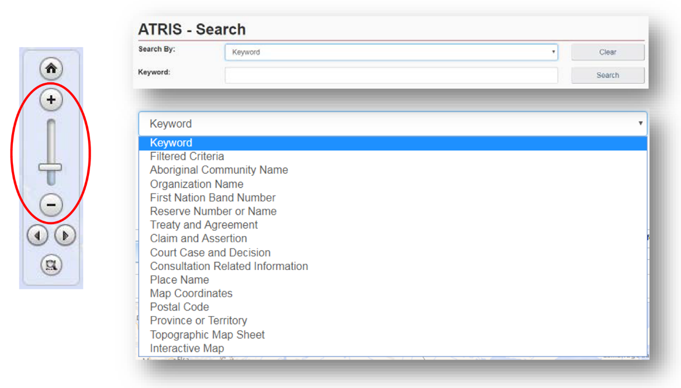
- Navigate to CIRNAC's publicly available ATRIS web-based application
- Navigate to the project location in the map viewer, either by clicking, dragging, scrolling to zoom, or using the various search options available in the 'Search By:' drop down menu.
-
Draw your project on the map in the exact location using the "Draw on map" tools drop down located in the top right of the ATRIS interface. You may draw as many components of varying types (point*, line, polygon) as necessary to be saved as one single .KML file.
*Endnote: ATRIS users will not be able to create a geometry "point" in GIS terms, but the "Circular Search" option allows users to create circular polygons able to mimic points in terms of scale
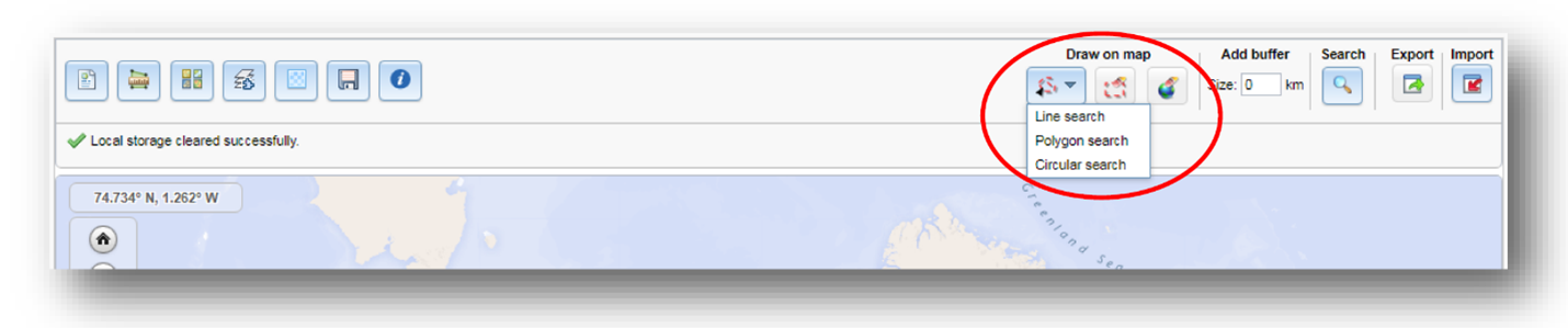
Choose the appropriate drawing tool for the type of component you are drawing:
- Line search:
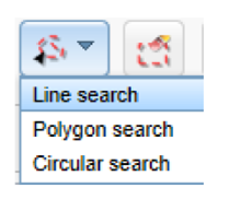
- Click as many times as necessary to create a line that represents your linear project feature. Double click to complete.
- Examples include roads, sewer lines, railways, pipelines, trails, transmission lines, etc.
- Polygon search:
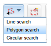
- Click as many times as necessary to create a closed polygon that represents the project feature. Double click to complete.
- Examples include building footprints, vegetation cuts, sewer/wastewater lagoons, etc.
- Circular search:
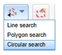
- Click on the map to automatically create a circle. To create a smaller circle similar to a point, zoom in as close as possible on the map before clicking. Alternatively, click and drag, then release to draw a circular project feature yourself.
- Examples include wells, outfalls, culverts, etc.
- If at any time you wish to erase anything you've drawn, use the following two options:

- Erase by Extent: Click and drag to create a shape around what you want to delete. Anything intersecting the box will be deleted when you release it.
- Global Erase: This will erase everything on the map. Click OK when prompted to clear the map viewer and start fresh.
- Line search:
- Once you are satisfied with the drawn representation of your project, click the 'Export' button.
- The .KML will download as 'SearchAreas.kml (unless you have specified otherwise) to the location where your browser saves downloads.
- The file name can be changed to something that reflects the project name before sharing it to INFC.
Once saved, the .KML file is ready to be uploaded or sent via email.
Should you need any further assistance with ATRIS, please visit the following link to find more information about ATRIS training webinars.
Using Google Earth
If you already have Google Earth installed on your operating system, please disregard Step 1.
- If you do not have Google Earth (free) installed on your system, follow the download instructions.
- Navigate to your project location using one or more of the following options:
- Typing an address or coordinates in the search bar (a).
- Clicking, dragging, and scrolling in the map viewer (b).
- Using the navigation tools (c).
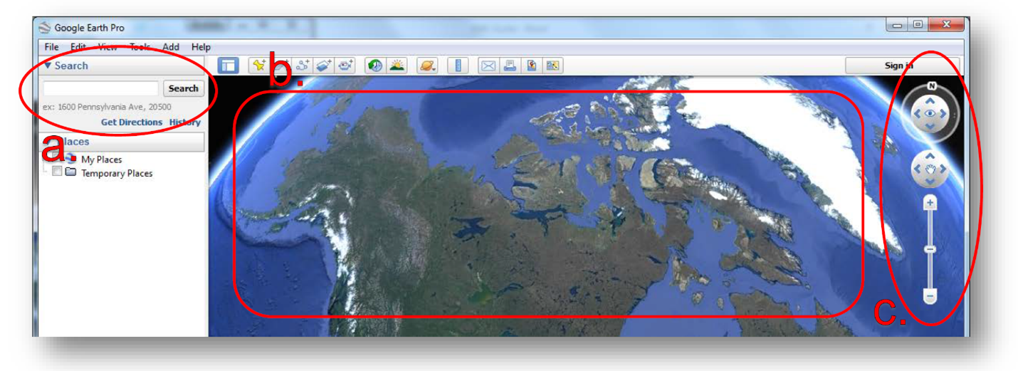
-
Draw your project on the map in the proper location using the placemark, polygon, and path tools (pictured below). You may draw as many components of varying types (point, line, polygon) as necessary.
Choose the appropriate drawing tool for the type of component you are drawing:
- Placemark: point project components
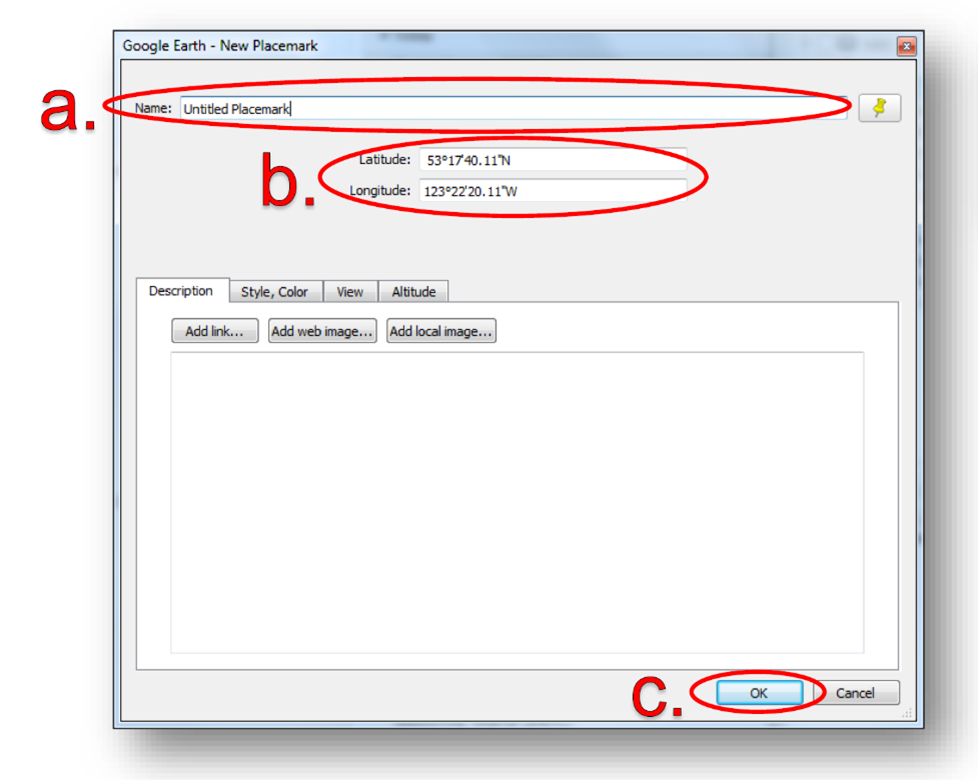
- Examples include wells, outfalls, culverts, etc.
 Clicking this button will add a placemark to the map and bring up a corresponding dialogue box.
- You can rename the placemark by changing the entry in the 'Name' field of the dialogue box (a).
- You can move the placemark by clicking and dragging it to the desired location or entering the desired latitude and longitude coordinates in the dialogue box (b).
- Click 'OK' when finished (c).
- Polygon: project components that consist of an area of any shape
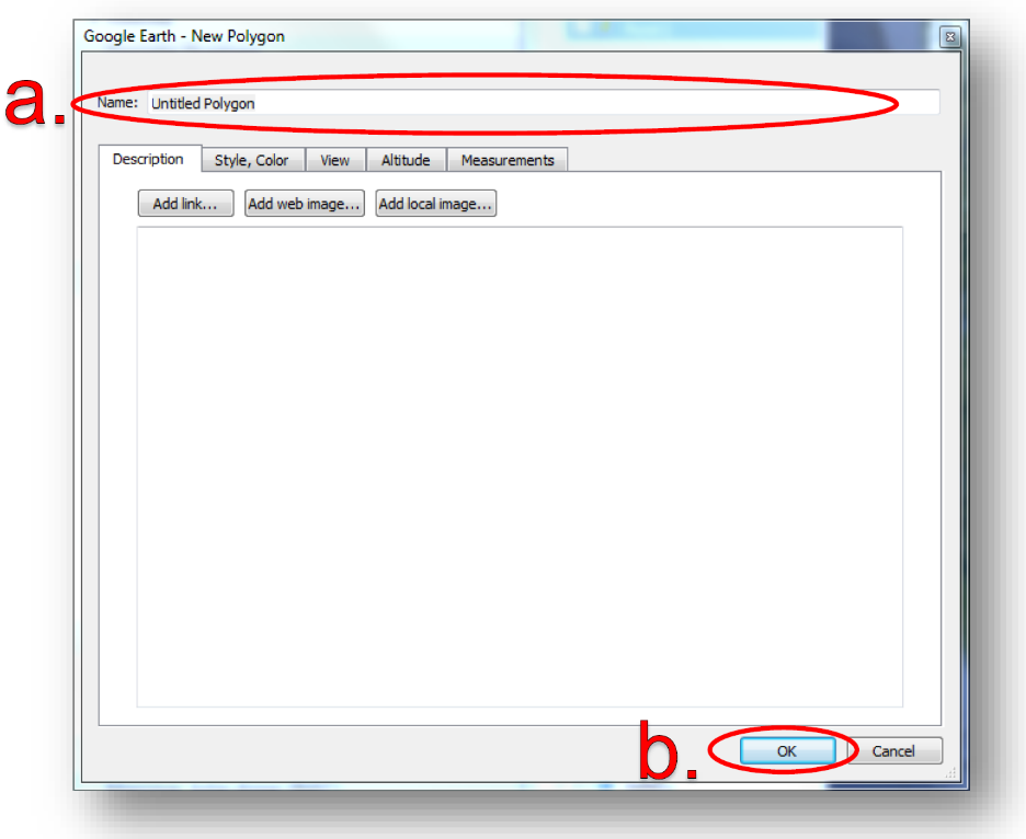
- Examples include building footprints, vegetation, sewer/wastewater lagoons, etc.
 Clicking this button will bring up a dialogue box and a crosshair cursor (see below).
 - Click as many times as necessary to create a closed polygon that represents your project feature.
- You can rename the polygon by changing the entry in the 'Name' field of the dialogue box (a).
- Click 'OK' when finished (b).
- Path: linear project components
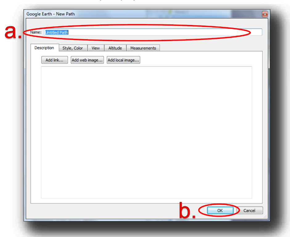
- Examples include roads, sewer lines, railways, pipelines, trails, transmission lines, etc.
 Clicking this button will bring up a dialogue box and a crosshair cursor (see below). Click as many times as necessary to create a line that represents your project feature.
- You can rename the path by changing the entry in the 'Name' field of the dialogue box (a).
- Click 'OK' when finished (b).
All drawn components will appear in the 'Places' sidebar under the 'Temporary Places' folder.
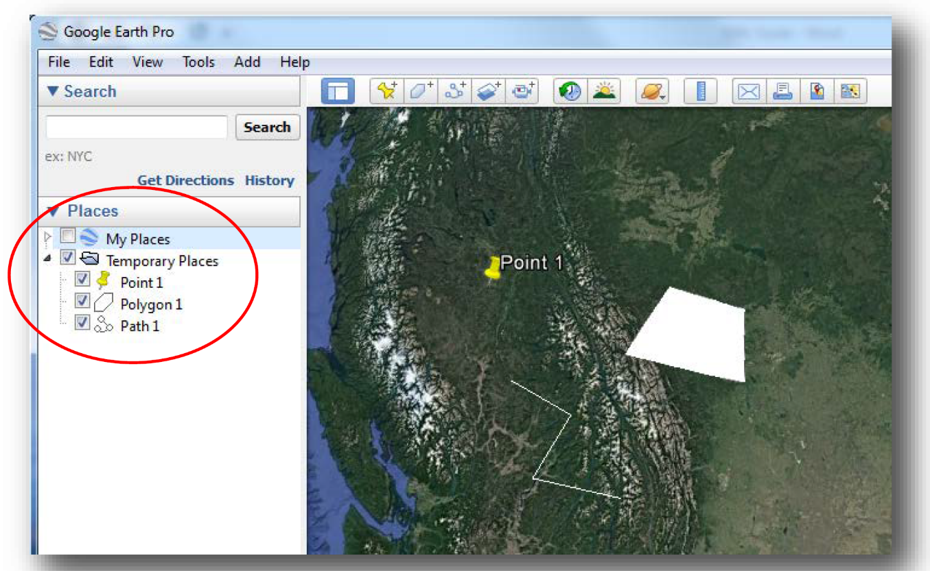
- Placemark: point project components
-
Export the shapes to .KML to be shared.
Warning: If you have multiple shapes, they will need to be exported individually as separate .KML files.
- Right-click on the component in the 'Places' sidebar and click 'Save Place As…'.
- Change the file type from .KMZ to .KML using the 'Save as type:' drop-down menu.
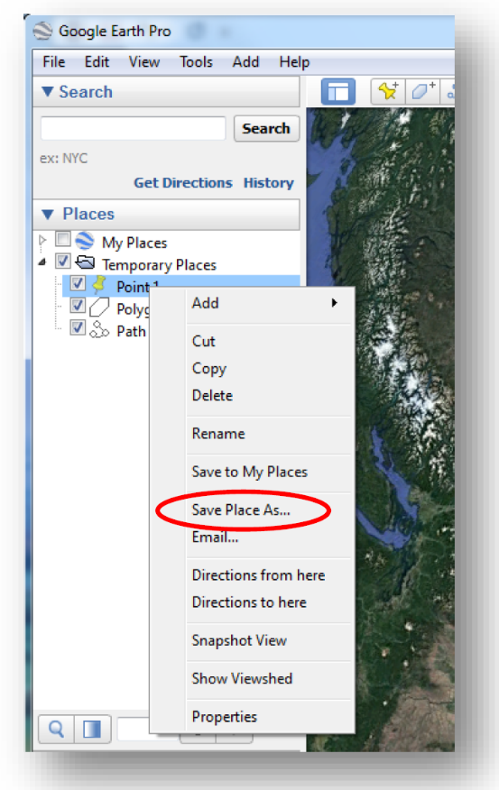
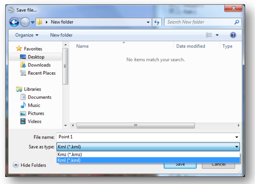
- Choose the location where you would like to save the file in the file browser. You will need to locate it, later on, to send it to INFC.
- Click 'Save' when you are finished. You are now ready to upload the file in the Applicant Portal.
Repeat Step 4 for as many project components as you have created if you have more than one.
Report a problem on this page
- Date modified: